

 Apple TV + F1")

 Alexa+ Free with Prime get Nikki")


Intense lake-effect snow bands slam Great Lakes, shifting east as winter blast spawns dangerous crashes
Bands of lake-effect snow are intensifying across parts of western New York and Ohio after creating whiteout travel conditions along the southern shores of Lake Michigan, while snow earlier Wednesday delayed thousands of flights into and out of the Midwest.
CHICAGO – Bands of lake-effect snow are intensifying across parts of western New York and Ohio after creating whiteout travel conditions along the southern shores of Lake Michigan, while snow earlier Wednesday delayed thousands of flights into and out of the Midwest.
Widespread snow is expected downwind of Lakes Erie and Ontario and into the interior Northeast. Winter Storm and Lake-Effect Snow Warnings are in place through Thursday morning.
The Cleveland metro area in particular should see consistent lake-effect snow and potential whiteout conditions through the morning.
Meanwhile, the lake-effect has begun to taper along Lake Michigan in Michigan and Indiana, where more than a foot of snow has piled up since Wednesday afternoon. More accumulation is expected in that area into Thursday afternoon.
FOX Weather Correspondent Robert Ray was live Wednesday evening in Benton Harbor, Michigan as the strong lake-effect snow took hold Wednesday night, packing high winds that sent snow and sand sideways.
"My goodness it is roaring right now. It feels like a tropical storm, but then you add freezing cold temperatures with the wind and the snow and it makes it even more uncomfortable than when you're in those tropical scenarios," Ray said.
WHAT YOU SHOULD KNOW ABOUT BLOWING, DRIFTING SNOW
The intensity of the storm forced even winter-adjusted cities like Benton Harbor and Michigan City, Indiana to close municipal buildings early Wednesday afternoon.
A trifecta of forecast ingredients kicked the lake-effect snow machine into high gear, as winds were perfectly aligned to tap into the abundant moisture over the relatively warm waters of both Lake Superior and Lake Michigan.
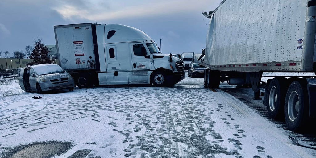
Farther east in Elkhart County, Indiana, at least 10 semi-trucks were involved in a 30-vehicle pileup on Interstate 80 Wednesday afternoon.
AT LEAST 10 SEMI TRUCKS INVOLVED IN MASSIVE CAR PILE-UP IN INDIANA
State police told FOX Weather that blowing snow greatly reduced visibility.
A flash freeze plunged temperatures as much as 10 degrees in an hour across some places in the Ohio Valley, setting the stage for additional dangerous driving conditions for the evening commute.
Chicago's O’Hare International and Midway International airports reported quarter-mile visibility Wednesday morning after Snow Squall Warnings were issued late Wednesday morning.
More than 1,000 flights were delayed into and out of O'Hare alone Wednesday.
AIRPORT GROUND STOPS VS. GROUND DELAYS: WHAT ARE THEY AND HOW DO THEY HAPPEN?
The snow will wind down across the Great Lakes through Thursday evening. More than 5 inches of snow is likely across the Buffalo, New York metro area downwind of Lake Erie, all told.
The initial cold front responsible for the winter weather blasted the Appalachians Wednesday.
Snow was reported across West Virginia’s Allegheny Mountains and into the Blue Ridge Mountains of Tennessee and western North Carolina.
Winter Alerts remain in effect for higher elevations through Thursday morning.
The post Intense lake-effect snow bands slam Great Lakes, shifting east as winter blast spawns dangerous crashes appeared first on Fox Weather


